


YORK 1, Dearborn County, Indiana
About
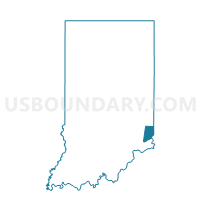
Outline

Summary
| Unique Area Identifier | 576779 |
| Name | YORK 1 |
| County | Dearborn County |
| State | Indiana |
| Area (square miles) | 18.59 |
| Land Area (square miles) | 18.59 |
| Water Area (square miles) | 0.00 |
| % of Land Area | 100.00 |
| % of Water Area | 0.00 |
| Latitude of the Internal Point | 39.19088880 |
| Longtitude of the Internal Point | -84.96365370 |
Maps


Graphs
Select a template below for downloading or customizing gragh for YORK 1, Dearborn County, Indiana


Neighbors
Neighoring Voting District (by Name) Neighboring Voting District on the Map
- JACKSON 1, Dearborn County, IN
- KELSO 2, Dearborn County, IN
- KELSO 3, Dearborn County, IN
- MANCHESTER 1, Dearborn County, IN
- MANCHESTER 2, Dearborn County, IN
- MILLER 1, Dearborn County, IN
Top 10 Neighboring County Subdivision (by Population) Neighboring County Subdivision on the Map
- Miller township, Dearborn County, IN (9,810)
- Manchester township, Dearborn County, IN (3,215)
- Kelso township, Dearborn County, IN (2,341)
- Jackson township, Dearborn County, IN (1,705)
- York township, Dearborn County, IN (1,221)
Top 10 Neighboring Unified School District (by Population) Neighboring Unified School District on the Map
- Sunman-Dearborn Community School Corporation, IN (24,824)
- South Dearborn Community School Corporation, IN (17,247)
Top 10 Neighboring State Legislative District Lower Chamber (by Population) Neighboring State Legislative District Lower Chamber on the Map
Top 10 Neighboring State Legislative District Upper Chamber (by Population) Neighboring State Legislative District Upper Chamber on the Map
Top 10 Neighboring 111th Congressional District (by Population) Neighboring 111th Congressional District on the Map
Top 10 Neighboring Census Tract (by Population) Neighboring Census Tract on the Map
- Census Tract 807, Dearborn County, IN (6,116)
- Census Tract 801.04, Dearborn County, IN (3,990)
- Census Tract 801.01, Dearborn County, IN (2,919)
- Census Tract 802.01, Dearborn County, IN (2,341)